Best Foot Forward: A satisfying saunter from Sowerby


The leaflet, “Walks around Sowerby” is one of many that are available to buy for £1 both online - http://heartofthepennines.org.uk/shop/ - and in local visitors’ shops, and almost all towns and settlements in the region are covered by the series, offering a huge variety of routes to choose from. Many new leaflets have been published this year, and they provide maps and route guides, as well as pieces of local history to spot whilst out on a ramble.
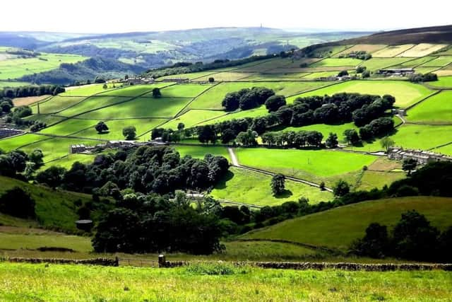
I would recommend this walk highly to beginners. There are no steep climbs, it is not lengthy, and with little effort the beautiful views of the Calder Valley reward you, looking towards Sowerby Bridge and Luddenden; gaining height with ease.
Advertisement
Hide AdAdvertisement
Hide AdWe began at St Peter’s Church in Sowerby, HX6 1HA, [GR SE 042 232], which was re-built to replace an earlier building that had stood since 1592. I have been told that a local wealthy businessman, George Stansfeld, whilst contributing to the building of the new church in the 1760s and purchasing parts of the old building to incorporate into his nearby property, Field House, also had sufficient influence to ensure that the front of the church, facing towards Field House, was pretty and ornate, but leaving the rear of the church rather plain!
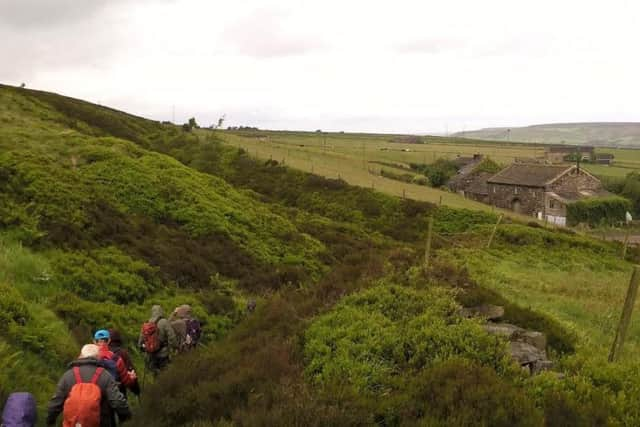
Leaving the village, walk toward the Church Stile Inn and turn left to descend Pinfold Road. Turn right, leaving the road and joining a single track, heading towards the valley floor.
You will pass Wood Lane Hall, a Grade 1 listed building which has stood since the 1649.
Built by a wealthy yeoman clothier, John Dearden’s family were renowned for lavish entertaining after the death of family members, with one funeral in 1672 attracting nearly 300 guests and another wake offering mourners 26lbs of biscuits, fourteen gallons of wine as well as an abundance of meat and produce as a distraction from their grief!
Advertisement
Hide AdAdvertisement
Hide AdYou will cross the railway line at the bottom, via a bridge after which you immediately turn left, following the railway with the river and canal to your right. Re-crossing the railway, the path will split and you turn left to rise slightly, crossing a stile.
You will pass through two fields, meeting a minor road [Styles Lane, GR SE 039 239] and in front of a terrace of houses, turn right into Finkle Street. Finkle is a word of Nordic origin, implying a corner or bend, particularly on a narrow street. At the end of the terrace, bear left up past Swamp Cottage and you will climb to the sound of running water coursing its way down the clough. At the top turn right where you will see a very large drainpipe emerging from a concentre wall. Follow the path bearing right, passing very close to the houses through a narrow passage. You’ll notice a curious turreted building above you on the left; you get a better view shortly, having ascended a flight of steps with a phone box at the top. Here, turn right, walking along Acre Lane, where shortly up ahead you’ll see a way-marked path to the left. Take this; it passes a barn and you walk between the houses, passing through a narrow, gated corridor.
The path curves around a field edge and you will reach another tarmac road where you continue the gentle climb, past Shroggs Farm. There’s a sharp bend at Hollins Gate and a path way-marked to your left [GR SE 030 243]. Enter the field and walk as far as the stile, but don’t cross over it, instead turn right, following the field edge next to a wall. You reach New Lane, a minor road. Behind you the valley stretches towards Sowerby Bridge and Luddenden is also visible.
Just to your right the path continues ahead to Moor Bottom Lane where again go right then left, following a dead straight track until a cross roads. Here turn left and you follow the gravelled track to reach tarmac, turning right [this is marked Moor End on the map, GR SE 022 236]. Follow the way-marked bridleway, signposted Long Edge Road, before taking another Bridleway on the left. Follow this route and cross a stile on the left as the path heads right. Cross the field, passing through a gap in the wall, keeping the wall to your left and then turning right onto Wine Tavern Road. Mirey Lane is a left turn, leaving Wine Tavern Road and continue along a track past Far Fields Farm. Skirt the edge of the field and you’ll meet another road, marked Higham on the map. Turn right, you’ll see Sowerby up ahead and could take this road back to the start. However, to add a little, descend left following a bridleway at Stones Farm.
Advertisement
Hide AdAdvertisement
Hide AdThis will take you back towards Boulder Clough, through which you passed earlier; again you see the turreted house. Boulder Clough was where the Ancient Order of Henpecked Husbands met every Easter Monday in the Methodist Chapel to simply escape the burden of marital and domestic life. Claiming to have roots dating back to 3980 BC, this ‘branch’ began in the 1890s as a rambling group by Methodist Ministers. It was only finally disbanded in the 1970s. Much more information on this group, and the area itself, can be found on www.sowerbytown.org.uk. Turning right, follow the road back up towards Sowerby and you’ll see the Church Stile Inn at the top. A pleasant, gentle ramble, perfect for an afternoon stroll.