Best Foot Forward: Wilderness on your doorstep


If you want to walk on an afternoon, yet the car still needs to be washed or the lawn mown; this short route gives you a breath of fresh air on a day otherwise scheduled with chores! At 6.5 miles long, it can be covered in relatively short time due to the ease of the terrain [mostly flat] but offers outstanding views along the way.
Beginning from Ogden Reservoir car park, GR SE 066 309, postcode HX2 8YA [£1 charge and can get very busy at the weekend with up to 2000 people visiting per day in the height of summer!] this route heads firstly onto and across Ovenden Moor, before bearing north-west onto Thornton Moor, and returning along the Bronte Way. The Bronte Way runs a total of 44 miles from Gawthorpe Hall in Lancashire, finishing at Oakwell Hall close to Birstall, taking in places that inspired the novelists, featured in the books and, of course, Haworth itself where the Bronte family resided. There are numerous circular walks that can be done using parts of the route and you can by a book detailing these.
Advertisement
Hide AdAdvertisement
Hide AdWe passed the visitor centre and crossed the reservoir dam, continuing along the obvious track onto the moorland, passing Halifax golf course on our left. This is a long, gentle ascent, but the only climb of the route. Passing through a metal gate, up ahead there is a building that was once a pub, and there is a clear way marker on your right, traversing another gate [GR SE 047 308]. Taking this path, which is clear, you will cross a footbridge at the very top of
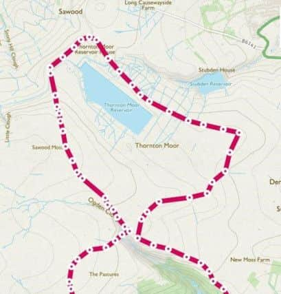
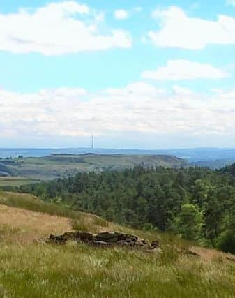
Skirden Clough [which is one of two streams that feed the reservoir] and walk past the rather majestic, or incongruous-looking, wind turbines, depending on your point of view! The site of this wind farm is rated among the top ten windiest in-land sites in the UK.
At this time of year, the ground is solid, however having walked here many a time, it can become rather boggy rather quickly, but the path is very clear to follow [It is thought that the name “Ogden” is derived from a corruption of the word bog]. You’ll reach another dip in the landscape and descend steps to cross the weir. There’s a great place to pause, under a tree, nestled in the clough. Climb up the steps the other side and turn left to follow another distinct track. At one point there appears a path going off to the left, follow the right-hand path instead. You’ll see on the map Thornton Reservoir; however this does not become visible until the last minute, due to the contours. On the horizon are the hills of the southern Yorkshire dales; the hues of the landscape changing from the lusher greens of meadows to the ashy-grey- green of the moorland-proper. You can see the buildings of Oxenhope up ahead, with
isolated farms and houses dotted on the hillsides around.
With the reservoir to your right, continue slightly beyond the end of the water where there is a prominent way-marker indicating the Bronte Way going right. Follow this along the track, before curving again to the right and following an unpaved road, Thornton Moor Road back towards Ogden. About 1km after the end of Thornton Moor Reservoir and just beyond Stubden Reservoir, there’s a clear path turning across the field to your right, marked by a wire fence either side [GR SE 064 327]. Crossing the field, you’ll climb over a stile to meet another unpaved road.
Advertisement
Hide AdAdvertisement
Hide Ad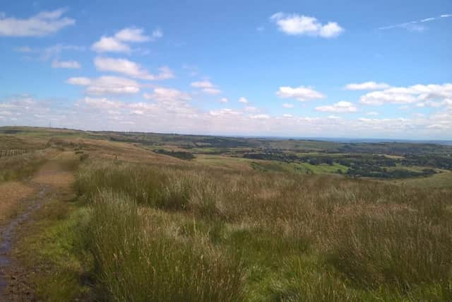
Having intended to take the path shown on the map continuing straight ahead, we found it so un-used that it couldn’t be followed, and not being open access land, we did not want to trespass, thus retreated back to the unpaved track. A kind local stopped in his car to tell us that there was a path where we’d intended to go, but it was not clear, so suggested following the track up past an old ruined building, beyond which at the top becomes a
bridleway.
Over the peak you’ll see the weir that was crossed earlier in the walk and here follow the path as it turns left back towards Ogden Reservoir, the edge of which is visible beyond the trees, which consist of many species – Larch, Birch, Sycamore with a majority of Scots Pine trees; the earliest parts of the woodland were planted around 1903. The Ogden Reservoir website is a great source of useful information such as this.
Pass through a metal gate and leave the bridleway, taking the footpath way-marked on the right. This slowly descends towards the woodland, passing the remains of a Roman road, and meets a track taking you back to the car park. If you pick a sunny afternoon, you can reward yourself with an ice cream from the van that is often found there throughout the summer!
As said, a short, easy walk perfect for those who are short on time but not short on desire to escape into the great outdoors. Also ideal for beginners as it is clearly way marked and with so many features of the landscape from which to orientate yourself, getting lost would be unlikely.